The collections of the Department of Maps in the Museum of Cieszyn include the oldest (1724) map of the Duchy of Cieszyn with Latin text serving as a regional advertisement of that time.
Translation into Polish is as follows:
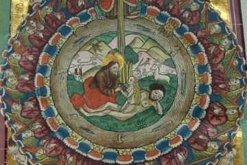
In the Carpathian Mountains, which form the boundary between the Silesia, Duchy of Cieszyn, Moravia, Hungary and Poland, a certain species of extraordinarily large sheep grazes throughout the year. All sheep are horned and the horns are unusually bent downwards. They feed on exquisite herbs growing abundantly in the mountains. The sheep-breeders live in huts built sparsely in the mountains and called sheds in the Slavic language. The milk is considered to be the most effective remedy for gout treatment. People suffering from this disease come here, especially in May, when the medical power of the herbs is the strongest; they drink the milk throughout the month; many of them have been cured so far this way, which is evidenced by multiple examples in these areas. This note is cited in order to describe the provided drawing.

The aim of the text is to inform potential readers about the unique qualities of the Duchy of Cieszyn areas and invite them to use the unique properties of the region. Phrases like: Extremely large fruits, (…) excellent herbs, (…) the most effective remedy, (…) many of them have been cured so far strengthen the information in a persuasive way. The advertisement was targeted mainly at the rich who often suffered from the “disease of kings”, i.e. gout, in the 18th century.
The drawing attached to the map presents a noteworthy scene of disease treatment and strengthens the information. The disease treatment side is a mountain shed, around which there are standing five men. The first one on the right, standing at the sheep enclosure, holds the horns of a giant ram who is penned by a hunting dog. Behind him, on the left side there is a shed, inside of which a man seems to be preparing the milk products for treatment. Close to him there is a person who plays the horn – folk wind instrument used to call up the animals and communicate with the shepherds or their families living in the valley. Next to the left, at the tree, there is a sitting rich Lord, probably waiting for the “milk treatment”. Next to him there is a standing man who holds a hat as a sign of greetings in his right hand and a hatchet in the left hand.
The first preserved map of Cieszyn Silesia is made in accordance with the perspective drawing method, involving presentation of elevations, which are shaded on the Eastern or South-Eastern side. The topographic profile is often deviating in terms of shapes from the actual conditions, sometimes gaining a fancy look. The following mountain peaks can be found on the map: Klein Czantorj (Small Czantoria), Gros Czantorj (Great Czantoria), Wróżna (probably mistaken for Ostre), Stożek, Karolówka (mistaken for Beskidek), Baranj (Barania), Cienków upon Tenkow (Malinka), M. Sczirk (Skrzyczne). Unfortunately, the map does not specify their heights. The drawing of a river network also includes some mistakes, which can be noted in particular with relation to mountain areas and map edge areas. Additionally, the discussed topographic presentation of the Duchy of Cieszyn includes many ponds, which are actually located in different locations. The largest number of presented objects relates to settlements, which are split by size, importance, etc. The map specifies the following: urbs celebris (the main city), the town, arx et castellum (castle and fortress), pagus cum templo (village with a church), pagus fene templo (village without a church), villa (small village), vicus (individual houses), which totals 520 identifications. Forty four circle symbols with dots mean locations with disease treatment locations. The map also provides data on the locations of paper making plants or ironworks. A surprising fact is the lack of roads on the first map of the Duchy of Cieszyn; however, it is more clear and legible this way. The territory of the Duchy of Cieszyn is marked with blue, green marking is used for the separate counties of Bilicensis (Bielsko) and Oderbergensis (Bogumin) and red marking relates to Fridecensis (Frydek) county. Some villages and towns were incorrectly identified in terms of location, which is a result of the erroneous field examinations, with rough examination of the topography in many cases.
The unique first Polish map of the Duchy of Cieszyn kept in the Cieszyn Museum is one of the versions of Johann Nigrinus map. It was copied from a copper plate by the engraver, J. L. Andrea. It includes a twin copy kept in Opawa and an older, related version held in Brno, made by Nigrinus himself; however, the latter includes differences relating to the text, drawing and map look. The above-mentioned first edition did not include the text concerning the health-giving sheep, milk and herbs. It is dedicated to the owner of Cieszyn’s land, Leopold Lotaryński. Its workmanship shows the lack of drawing skills of the author. Differences relate also to the framing vignettes with the map title – the older version includes the presentation of contemporary border guards and additional year of publication – 1724, whereas the newer version (Museum copy) presents the Hungarian Haiduks.